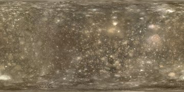
A map of Callisto
This map of Callisto was created back in the year 2000 from 78 images obtained by the Voyager and Galileo spacecraft. Most of these had a resolution of 0.7-4 km/pixel. The main exception is that using lower resolution images was necessary to colorize the map. The main reasons are that Callisto has not been globally imaged in color at high resolution and the weird color filter combination used for imaging at high resolution.
There is more detailed information about this map and how it was created on another page.
Click the map below to get the full size map (1800x900 pixel 424 KB JPG). The map is in simple cylindrical projection with latitudes running with a uniform interval from -90 (bottom) to 90 (top) and longitude 0 at the left edge of the map. It should be rendered by projecting it onto a sphere of 2409 km radius or some equivalent unit.
A "mask" map is also available below. It indicates which areas in the above map contain mainly fictional/cloned data and which areas contain real data. The areas containing fictional/cloned data are gray; other areas are black. Click the map below to download the full-size mask.